#1 Everyone In The World Could Fit Into A 50km Diameter Circle
After you’re done with the post, check out our previous articles featuring some of the most interesting maps here and here! More info: Instagram, Facebook Image source: amapaday
#2 ‘Nobody Lives Here’, 1x1km Areas In The United Kingdom Where The Reported Population Equals Zero
Image source: amapaday
#3 Sharks vs. Humans (2014)
Image source: amapaday
#4 Global Distribution Of Penguins
Image source: amapaday
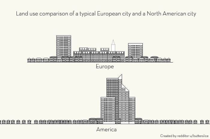
#5 Land Use Comparison Of A Typical European City And A North American City
Image source: amapaday
#6 The United Pixels Of America
Image source: amapaday
#7 The North American Cryptid Map
Image source: amapaday
#8 Cause Of Death – Reality vs. Google vs. Media
Image source: amapaday
#9 How To Read Tree Rings. The Color And Width Of Tree Rings Can Provide Snapshots Of Past Climate Conditions
Image source: amapaday
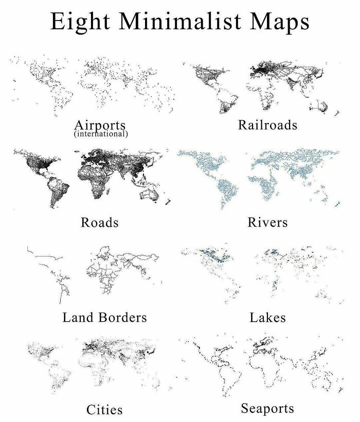
#10 Eight Minimalist Maps
Image source: amapaday
#11 Most-Used Word In Each State
Image source: amapaday
#12 Visual Guide To Geographic Terms
Image source: amapaday
#13 States With A Smaller Population Than Los Angeles County
Image source: amapaday
#14 When Two City Planners Hate Each Other (Missoula, Montana)
Image source: amapaday
#15 The Many Flags Inside Norway’s Flag
Image source: amapaday
#16 Closeness Over Time
Image source: amapaday
#17 The Timeline Of A Tree
Image source: amapaday
#18 Using The Statue Of Liberty To ‘Map’ How Copper Goes Through The Oxidation Process
Image source: amapaday
#19 How The Solar System Travels Through The Galaxy
Image source: amapaday
#20 A Bar In Dc Made A Us Map From One Summer’s Confiscated Fake Id’s
Image source: amapaday


title: “20 Of The Most Interesting Maps Shared By This Instagram Page To Teach You Something New” ShowToc: true date: “2024-10-19” author: “John Blumhardt”
#1 Everyone In The World Could Fit Into A 50km Diameter Circle
After you’re done with the post, check out our previous articles featuring some of the most interesting maps here and here! More info: Instagram, Facebook Image source: amapaday
#2 ‘Nobody Lives Here’, 1x1km Areas In The United Kingdom Where The Reported Population Equals Zero
Image source: amapaday
#3 Sharks vs. Humans (2014)
Image source: amapaday
#4 Global Distribution Of Penguins
Image source: amapaday
#5 Land Use Comparison Of A Typical European City And A North American City
Image source: amapaday
#6 The United Pixels Of America
Image source: amapaday
#7 The North American Cryptid Map
Image source: amapaday
#8 Cause Of Death – Reality vs. Google vs. Media
Image source: amapaday
#9 How To Read Tree Rings. The Color And Width Of Tree Rings Can Provide Snapshots Of Past Climate Conditions
Image source: amapaday
#10 Eight Minimalist Maps
Image source: amapaday
#11 Most-Used Word In Each State
Image source: amapaday
#12 Visual Guide To Geographic Terms
Image source: amapaday
#13 States With A Smaller Population Than Los Angeles County
Image source: amapaday
#14 When Two City Planners Hate Each Other (Missoula, Montana)
Image source: amapaday
#15 The Many Flags Inside Norway’s Flag
Image source: amapaday
#16 Closeness Over Time
Image source: amapaday
#17 The Timeline Of A Tree
Image source: amapaday
#18 Using The Statue Of Liberty To ‘Map’ How Copper Goes Through The Oxidation Process
Image source: amapaday
#19 How The Solar System Travels Through The Galaxy
Image source: amapaday
#20 A Bar In Dc Made A Us Map From One Summer’s Confiscated Fake Id’s
Image source: amapaday
